
Mapping
Background on FEMA Maps
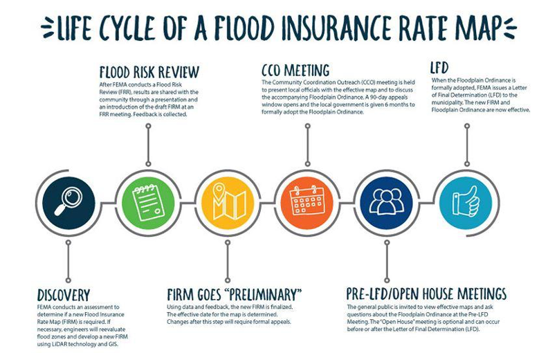
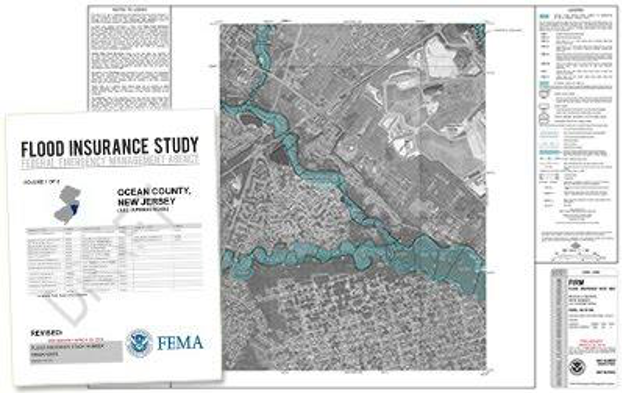
When each community joins the NFIP, they receive a map created by FEMA showing the flood risks in their community. The first maps created were known as Flood Hazard Boundary Maps (FHBMs). More accurate Flood Insurance Rate Maps (FIRMs) were later released. The community also receives a detailed Flood Insurance Study (FIS) report which provides a narrative and mathematics of the flood risk. More recently, FEMA has been working to digitize and update flood maps by community, since the original maps are in paper form – these are called Digital Flood Insurance Rate Maps (DFIRM).
The FIS and FIRM are created by using LIDAR/GIS along with a Hydrology & Hydraulic (H&H) Study. Preliminary maps are then sent to the community to review if the information is correct. Once approved, FEMA publishes the map, which becomes the “effective map.” The community must use the most recent effective map for insurance rates and flood regulations.
The maps define the Special Flood Hazard Area (SFHA), which is defined as “an area having special flood, mudflow, or flood-related erosion hazards.” Properties in the SFHA are required to obtain flood insurance if the community is part of the NFIP. Local floodplain ordinances monitor development in the SFHA, to lower increased flooding risks and prevent losses or damages.
Want more information on FEMA Flood Maps? Check out FEMA Publication 258: Guide to Flood Maps
FEMA Flood Map Service Center
All US flood maps (FHBMs and FIRMs) can be found at FEMA’s Flood Map Service Center. There are several ways to the use the website:
- Search by Address
- Type in a specific address to see an interactive flood map or to print a FIRMette (snapshot of a FIRM in PDF form)
- See map revisions and amendments for this property
- Search All Products
- Select State and County to find all products by community – current and historic
- County FIRMs will be listed as a community_all jurisdictions (i.e. ALLEGHENY COUNTY ALL JURISDICTIONS)
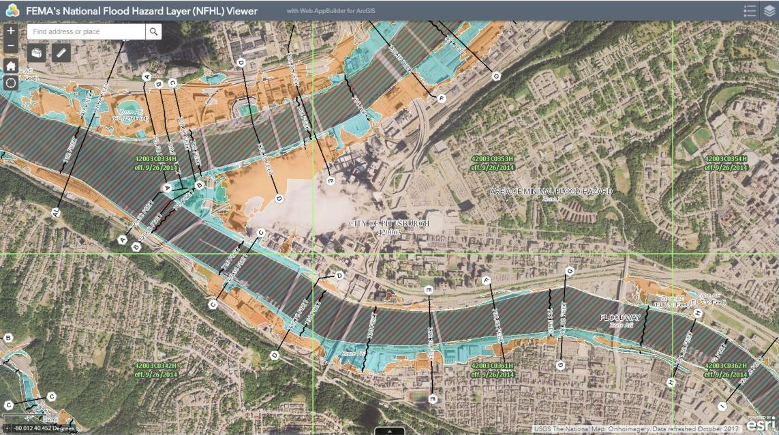
- Interactive National Flood Hazard Layer (NFHL) tool
- The NFHL is a digital compilation of all FIRMs for the country with aerial base map
- Search by address or zoom to location
- Print FIRMette of your map extent
- Legend shows symbology for each flood zone
Requesting Map Changes
FIRMs can be amended for various reasons, in several ways. All versions of maps and flood studies, including historical maps, can be found on FEMA’s Map Service Center under Products.
| Type of Map Change | Acronym | Purpose of Change (Definition from FEMA) | Who Submits the Change? |
| Letter of Map Amendment | LOMA | An amendment to the currently effective FEMA map which establishes that a property is not located in a Special Flood Hazard Area (SFHA). No change to FIRM. | Property owner or surveyor |
| Letter of Map Revision | LOMR | An official amendment to the currently effective FEMA map. It is issued by FEMA and changes flood zones, delineations, and elevations (FIRM is updated) | Local official or engineer |
| Conditional Letter of Map Revision-Fill | CLOMR | A conditional change of the current FIRM to show changes in the limits of floodplains, floodways, corporate limits, or flood hazard risk zones (no change to FIRM, until development is completed) | Local official or engineer |
| Letter of Map Revision-Fill | LOMR-F | An official amendment to the currently effective FEMA map, to show a particular structure/property has been elevated by fill and removed from being located in a designated SFHA (FIRM is updated) | Local official or surveyor |
| Conditional Letter of Map Revision-Fill | CLOMR-F | A conditional change and exclusion from the SFHA for structures and parcels proposed to be elevated by fill (no change to FIRM, until after development is completed) | Local official or surveyor |
Every map change is done with an MT form:
- MT-1 forms are for CLOMAs, LOMAs, CLOMR-Fs, or LOMR-Fs.
- MT-2 forms are for CLOMRs or LOMRs.
- MT-EZ forms are for LOMAs.
A map change can be submitted in paper form or through the eLOMA platform (for a LOMA) or the Online LOMC tool (for all other map changes). For more details, see FEMA’s information on the map revision process.
County Firms
- Allegheny County: Effective 09/26/2014
- Armstrong County: Effective 02/17/2016
- Beaver County: Effective 08/17/2015
- Butler County: Effective 08/02/2018
- Fayette County: Effective 07/18/2017
- Greene County: Effective 10/16/2015
- Indiana County: Effective 04/3/2012
- Lawrence County: Effective 01/18/2012
- Washington County: Effective 09/26/2014
- Westmoreland County: Effective 09/26/2014
Updated 02/01/2019
Your county’s effective FIRM is the most current data used to determine insurance rates. Your local ordinance and enforcement should reflect the current data shown on these maps. Find more information at FEMA Flood Map Service Center.
Explore Mapping Resources and Tools